Monday, August 28, 2017

Grand Portage - Land of the Anishinaabe**


It finally happened – I had a Black Tank Catastrophe!!!! I had my RV in to Hilltop Trailers (where I have always had excellent service) to fix my leaky black tank and gray tank valves. For those not in the know – Black Tank contains everything that goes down the toilet drain – Gray Tank contains everything that goes down the sinks and shower drains. My Black Tank valve had been leaking so I had put on a secondary valve as a second line of defense. Evidently – when I got my Black Tank valve serviced, the technicians failed to secure the secondary valve. I pulled the Black Tank valve and the secondary valve fell off causing sewage to run all over the ground. With my lightening reflexes, I closed the valve, but the damage had already been done. I won't go into the sensory details but let's just say that the air was ripe. After cleaning up the mess and checking to make sure all connections were in place and secure, I finished dumping. From what I hear, something like this will eventually happen to everybody in the RV world – I'm glad that I finally got this out of the way. Should be clear sailing from this point forward. Right?.......Right?

But onward to more genteel subjects. We traveled up the North Shore to the Grand Portage Lodge and Marina. The campground had full hookups which meant long slow showers. Always nice when that happens. We were in the middle of a field, but you could see Lake Superior off in the distance. It was one of those wild, windy, crazy weather weeks which always makes you feel like you are totally alive, battling the elements. I love weather like this.


On our way up the North Shore, we stopped at Naniboujou Club Lodge.  This lodge building was begun in the late twenties but the depression caused their grand schemes to be aborted.  They serve high tea here in the afternoon, but we just weren't up for cucumber sandwiches at the time, so we passed.  The main dining room has a ceiling which has been called a "psychedelic marriage of Art Deco and traditional Cree Indian patterns"


Besides Naniboujou, we came up here for two reasons. The first was to visit the Grand Portage National Monument. From Wiki:

The Grand Portage trail is an 8.5-mile (13.7 km) trail connecting Grand Portage with Fort Charlotte on the Pigeon River. Voyageurs from the interior of Canada would carry their furs by canoe to Fort Charlotte, and portage the bundles of fur to Grand Portage. There they met traders from Montreal, and exchanged the furs for trade goods and supplies. Each canoe "brigade" then returned to its starting place. The fur traders built Fort Charlotte as a trading fort at Grand Portage. There they built the Grand Hall in the French colonial style, which housed their meetings, a general store, and other facilities.[2]

What was rather unique about this National Monument is that they had Voyageurs enactors that would demonstrate or tell you about the Voyageurs lifestyle. I spent a lot of time speaking with a woman who was getting ready to bake bread in a old stone oven in the middle of the yard. Evidently bread was a luxury back in the day. It took four hours just to get the oven warm enough to bake bread. There was also an Ojibwa village where you could learn finger weaving or canoe building. Miko also got to play in Lake Superior and practice her wave catching skills.

The Grand Hall is on the right
They had a display of animal pelts in there - everything from a giant moose pelt to little tiny ermine pelts


Looking over Lake Superior

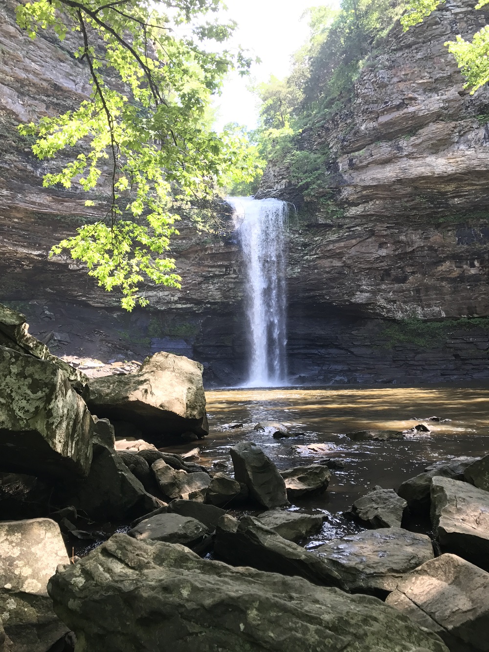
We also journeyed as far up the North Shore as you can go in the United States to the Grand Portage State Park. Actually, when you turn into the state park entrance, you can see the US border crossing into Canada. We had to come to this particular state park because it is the home of Minnesota's tallest waterfall at a height of about 120 feet. There is a nice gentle path and boardwalk that leads to the top of the falls. As you walk along, you can hear the falls, but then all of a sudden, you come upon them. It was almost as if they just leapt out and surprised you. I found that I liked these falls much more than the Wisconsin Tallest Waterfall that we had visited a few days earlier. It was probably because it seemed like there was so much more water or something.  Being the rather obsessive person that I am, I think that I may just have to visit the tallest/largest waterfall in every state now. 


High Falls on the Pigeon River


We could have made it home in one day's drive but why? We stopped in Cloquet Minnesota at the Spafford City Park Campground. This is a nice little campground located on an island in the middle of the St. Louis River. There were only a couple of campsites that had a river view which we did not get. Also on the island is the USG Corporation which is a 24/7 manufacturing plant. There was a constant hum from the factory but after a while it became sort of like white noise. More troubling was the fact that about 100 feet behind our campsite (hidden by trees and brush) was a train yard where they were constantly moving cars around. Once I fell asleep, I didn't hear anything but occasionally during the day, you would have thought that you were hanging out on the tracks about ready to get smooshed. On the positive side, there was a walking trail that crossed a bridge off of the island and was a wonderful place to walk Miko.  There was also a Frank Lloyd Wright designed gas station.  That man sure did get around.


Look - they have one of those cords that ding inside the building when you drive over it.
 I wonder if they actually come out and pump your gas for you.  Wouldn't that be a novel idea?


It's been awhile since you've seen Miko not look at the camera

**Anishinaabe - means the First People.  Anishinaabe are also called Ojibwa or the more current term is Chippewa.

Sunday, August 13, 2017

Waterfalls and Me

Waterfall Alert: Proceed with caution - I just can't help it.

We drove about 2 ½ hours up to Pattison State Park  which is just a couple of miles south of Superior Wisconsin. It was a nice easy drive. When we got there and because I really hate making reservations,  all of the electric sites were taken so we had to go to one of the sites with no electricity. I had half of a tank of water, my batteries were charged, so that was not a problem. Besides the length of the drive, the main reason to come here was that Pattison is the home of Wisconsin's tallest waterfall.

Manitou Falls stands at an impressive 165 feet. What was interesting was that these falls were not the crystal white gushing water falls that I normally think of. There was an awful lot of red water coming off the edge. Iron ore? Who knows – it was just different.


Big Manitou Falls - all 165 feet of her


Little Manitou Falls


We moseyed up the North Shore with a stop at Gooseberry Falls. I think I had pulled over once and done a quick look-see way back when, but this time I actually stopped to really look at the falls. You can't really live in Minnesota without seeing Gooseberry Falls – it is sort of like going to the State Fair and not getting cheese curds. It used to be that you had to just pull over to the side of the road and look, but they now have a very fancy, well-done Visitor's Center and paved paths down to the Falls


Lovely Gooseberry Falls - so scenic, so pristine, so private


NOT - there were tons of people here


Saturday, July 29, 2017

Whitewater


Whitewater State Park – southeastern Minnesota – No mosquitoes, no cell service and no wifi. But I have Tony so all is good. We came down here for a short little getaway.

Even though I am reluctant to make reservations, if you wish to stay in a Minnesota state park in the summer, you had better make one. I suppose it is because the summer camping season is so short and people are so anxious to get out and about. I lucked out in that I found probably one of the better sites available from Tuesday thru Thursday. Unaccustomed as I am to making reservations, I actually made the reservation thru Friday and then proceeded to set up a whole bunch of Friday appointments back home. Focus is perhaps a little weak at times. Luckily, the campground folk were understanding and refunded my money for Thursday night.

Tuesday, when we arrived was lovely. We set up our lawn chairs and just zoned out staring at all the mosquito free greenery. It is a real treat to be someplace in Minnesota in the summer without mosquitoes. They say it is because there is no standing water in the area, it is all moving streams and rivers.

Wednesday, it was supposed to rain but after a good soaking in the morning, it stopped raining. We decided that we would do the Chimney Rock hike. It was over 100 steps to reach the top of the bluffs. It was pretty steep but really lovely. When we get to the top of all of these steps, there is a map. I look at it and figure out which way I am supposed to go to get to Chimney Rock. Tony, knowing how map challenged I am chooses to sit on the conveniently placed bench and wait for my return. Clever man as I, of course, picked the wrong way. If I had gone left, Chimney Rock was maybe a five minute walk. I went right and walked for about a half hour before I decided that I was perhaps going the wrong way. It was really a pretty walk, there were several outstanding views over the river valley, but because of the rain, there was also a lot of slick mud. I'm really grateful that I had my walking stick. I never did get to see Chimney Rock, only the most popular sight to see at Whitewater. Oh well.


When we get back to the campsite, it starts to rain. My phone goes off with severe thunderstorm warnings. Ok, fine – but then the phone tells me we have a tornado warning also. It is pouring down rain. We decide we should maybe head for shelter in the campground shower house. As we are heading over there, a ranger drives up and tells us we need to evacuate. When we get to the shower house, I decide that we should go into the Women's side, the reasoning that it would probably be cleaner. I guess I was basing that on past experiences. Later on, we talked to some people who were in the Men's side of the shower house. His reasoning was that the southwest corner of a building is supposed to be the safest place to be in a tornado. Guess who had a more valid reason for which side to choose. Fun Fact: Southwest corner safety is a myth – no part of a building is safer than another during a tornado – staying away from windows is the key. We were in the shower house for about an hour and a half and eventually walked back to the campsite all safe and sound.

Miko, of course, chose the safest place to be

Later that night, we found that we were parked in the middle of a lake. Seriously, the water around the RV was above my ankles. My door mat was floating several feet away. By the next morning, most of the water had drained away but it was muddy. Since we were leaving that day, we decided to do a short hike around a meadow. Pleasant enough except for the parts where there was still standing water and we had to trail blaze around the little lakes on the trail.

Yes, the mat is floating

Since I had no cell service, when we left the park, I could not use my stand by travel assistant – Google Maps. We ended up going along some of the smaller highways, which I thoroughly enjoyed. These roads are always much more entertaining than the big interstates.

I would love to go back to Whitewater – maybe actually see Chimney Rock and do some more hiking. There were some new experiences and I got to share them with Tony. I'm not sure being evacuated to the shower house because of a tornado is something that will make him want to continue this camping adventure, but I guess it was a unique way to spend the night.

Friday, May 19, 2017

Home Again, Home Again


I spent a night in a little Missouri state park called Weston Bend. It is just a tad north of Kansas City and the sites were all nice, wooded and there were some trails to explore. There was also a dog park but I'm finding that dog parks really don't seem to thrill Miko too much. She is polite, greets other dogs, but just wants to stay with me and not go play with them.


West Bend State Park site

I moved on to Pender Nebraska, a small little town, in the middle of nowhere, in between Omaha and Sioux City. I had an appointment to get my tow bar serviced. I had been having trouble with the tow bar, the arms were intermittently not locking. This can cause all sorts of problems because if the tow bar is not locked and I take a turn, the tow bar could bend. As it was, when the technician took apart my tow bar, some of the innards were a little bit bent. He fixed me all up and I bought a few spare parts for future use. For $35 dollars, I got my tow bar fixed and I had a free place to stay. Such a deal. I won't mention how much I spent on spare parts.


Nebraska

This being Nebraska, there were severe thunderstorm warnings all night long. The next morning, during a break in the rain, we took off and ended up in St. James Minnesota. It was a miserable drive, intense downpours – but the roads themselves were not too bad. As soon as I got to St. James, my phone tells me that not only am I still under a severe thunderstorm warning but just for fun let's throw in a tornado watch. I've got my weather radio going and I am strategically parked next to the shower house which is the storm shelter. It can't be all that bad – off in the distance I'm seeing blue skies.

Got the RV all cleaned up and drove another two hours to my RV storage place. Made it safely, no car fires, no drama.  I drove for four days in a row - definitely too much for me nowadays.  I guess I have slowed down.  It is nice to be home. 

Wednesday, May 17, 2017

Eureka Springs


Eureka Springs – located about as far north as you can get in Arkansas without straying over into Missouri. At last count, there is supposed to be 63 natural springs – guess that is where the name came from. It used to be a mecca for people wanting to be healed but since the Health Department has declared that perhaps it is not maybe in your best interests to 'take the waters', Eureka Springs has become more of a tourist town.

As is my nature, when I first get to a town, I like to do a city overview, if possible. In Eureka Springs, this takes the form of a open air tram ride to most of the town sites. There were Victorian houses, the haunted Crescent Hotel, a 65 foot statute called Christ of the Ozarks and a very touristy downtown with very very narrow streets. I'm really glad I wasn't doing the driving. The guide was your typical corny tour guide but he seemed to have found his audience among the 48 tourists. The tour was about 90 minutes and it was a pleasant afternoon to be driven around.


There is a place called Quigley's Castle that I needed to see. In the forties, Mrs. Quigley designed a house which Mr. Quigley said he would build for her. She got a little impatient, waiting for him to build the house. One day, when he left for work, she and her children tore down the house they were living in. When Mr. Quigley returned from work, he had to resort to living in a chicken house. Mrs Quigley designed the house so it had two frames. The outside frame was decorated in rocks and shells that she had collected over the years. The inner frame was several feet inside the outer one and in that space between the two frames,there was no floor, there was just dirt where Mrs. Quigley planted a garden. Some of the two story plants that are there are over sixty years old. Mrs. Quigley had a lot of energy and ended up putting stones and crystals everyplace.


The Castle


Inner/Outer Frame

The Goldfish Tank


The second story - plants growing up from below


Mrs Quigley's Butterfly Wall - one whole wall in an upstairs bedroom


Mrs. Quigley collected rocks - Mr. Quigley collected bottles

My mother thinks I put too many pictures of rocks in my blog - Mom, it could be a lot worse


I felt guilty for leaving Miko alone and so when I got back we decided to go hike around Lake Leatherwood. I chose to do the four mile loop around the lake, forgetting, of course, all the rain that Arkansas had been literally flooded with. It was a nicely marked trail on the first half of the trail until we crossed the dam. There were several creeks that normally you could walk across on stones, but now were about ankle deep. I started regretting the fact that I had opted not to buy waterproof hiking shoes. At the very end of the trail, the flooding got even deeper. I let Miko off leash because of her tendency to try to hop over water. I knew she would pull me over. Somebody had tried to put some logs and boards across the waterway, which I used, but mostly I just resigned myself to getting wet.


How to get from here to there?


Blue Springs Heritage Center was the home of Blue Springs – a spring that pumps out 38 million gallons of water a day. The walkway around the springs was all flooded out – you could only walk on the upper walkway. It was sort of eerie looking down into the water and seeing a bench that was about three feet under water. It was a little like looking at the Lost City of Atlantis.


The water was actually this color


Upper walkway and stairs down to the lower walkway

Never one to turn down an opportunity for a Junior Ranger badge, I headed over to Pea Ridge National Military Park – site of a civil war battle. The ranger was unable to tell me the difference between a National Military Park and a National Battlefield, even though he said he had tried researching it. I hope he finds his answer. I watched the movie, drove the seven mile loop around the battlefield, impressed aforementioned ranger with the depth of my Junior Ranger answers and got my badge.


Monday, May 15, 2017

The Devil's Den


The nice thing about traveling in the middle of the week is that you can usually go to a super popular state park and they will have a camping space for you. Sometimes you might even be the only one in the whole park. Since I was traveling mid-week, I was able to pretty much take my pick at Devil's Den State Park in the Boston Mountains in northwest Arkansas. Even better, if I stood outside my RV, in a very particular spot, I would have on again, off again WIFI. The bad news is that I had no cell service at all. I panicked for a bit, because I didn't know about the lack of cell service and I knew Tony would be waiting on me to call for our evening chats. I guess we would have to rely on old-fashioned letter writing. Ok, perhaps that is a bit dramatic, when I could catch a WiFi signal, it would be email.

The Dam Waterfall Near the Visitor Center -


The first trail I was going to do was called the Yellow Rock Trail. It leads to a rock overhang where there is a great view (a long way down) over the valley. It is supposed to be three miles and take about two hours to hike. Somehow I got a little turned around and this hike ended up taking me five hours and many more miles. At one point, I came to a V in the trail. One leg seemed to go down a small hill and end at a cliff. The other leg looked like the trail continued. Nope – that leg dead ended. I went back to the V and could not figure out what to do. I decided to sit on a log and wait for another hiker to come along and that way I could just follow in their footsteps. After sitting there for an indeterminate amount of time and no hikers came along, I figured out that that strategy was not going to work. I crept out toward the edge of the cliff and there hidden behind a tree was a steep switchback going down the side of the cliff. Yay – I was saved. Perhaps I need to work on my wilderness skills a bit.

Yellow Rock - Miko again ignoring me


The other trail I did was called the Devil's Den Trail. It was a circular trail and it was a great deal of fun. You had to climb up and down rocks and try to figure out where the trail was. I found that when there didn't seem to be any way forward, if I just stopped and thought for a moment, a way would become clear. There was a baby waterfall on the trail and the last portion of the trail wandered by Lee Creek which was refreshing


Baby Waterfall


Saturday, May 13, 2017

I Say Petite, You Say Petty


I was reading my Arkansas Waterfall book and it said that the largest waterfall in Arkansas was at a state park called Petit Jean. When I consulted my Google maps, I found that the park was only an hour drive away and they had available campsites. Change of direction – change of plans. Off to Petit Jean State Park.

You would think that Petit Jean would be pronounced in the French way, but not in Arkansas. It is pronounced Petty Jean. You can read about the legend of Petit Jean here

Miko and I spent the first day at the park running around to all of the trails that were under a mile. Lots of rocks and lots of greenery. I saw the famous big Cedar Falls from an overlook, but I could only see the top half.


Palisades Overlook


I finally got Miko to look at me.  I had to trick her though - I took a picture when she was looking away and when she heard the camera click, she thought I was done picture-taking and looked at me. Sly little puppy.


Top part of Cedar Falls


I met a wonderful couple, who shall remain nameless, who had moved to Arkansas. We were talking around the campfire about traveling by RV to Canada and the gentleman said that he had a great deal of trouble getting into Canada – evidently Canada is a little touchy about letting people into their country with a police record. Never mind that the offense occurred over forty years ago. Never mind that it was a simple marijuana possession charge. Never mind that this gentleman had actually been pardoned by Governor Bill Clinton. Imagine, he actually had a piece of paper signed by the future president of the United States. I thought that was both a shame (Canada) and also very cool(Clinton).

I debated whether or not to hike the Cedar Falls Trail, which goes to the bottom of the Falls and was supposed to be the only way to see the Falls in all their glory. The trail was rated as strenuous and 'only those in good shape should attempt this hike'. The first half mile descends more than 200 feet down steps cut from rock by the CCC. This does not sound like my type of hiking. I wasn't too worried about the going down, it was the coming back up that had me worried. I decided to do it. What's the worst that could happen?

You had to be careful going down the first half mile. There was a lot of navigating down steep rocky switchbacks. I had to speak severely to Miko who forgot herself again in her never-ending lizard hunt and almost took us over the edge one time. Usually she is great on the trails, especially going downhill. She is quicker than I am going downhill and she knows that when she reaches the end of the leash, she needs to stop and wait for me to catch up. Otherwise she could pull me over flat on my face.

Once we got down the mountain, it was a lovely trail along the Cedar Creek until we got to the payload. Cedar Falls was beautiful. We sat down on a rock and just watched the water come down. It was cool and crisp and very idyllic. I found myself thinking “ok, when we get back, I've got to do this and I've got to do that and....” I had to tell myself to get back into the present moment. All that existed was these Falls – there was no past, there was no future. I ended up sitting there for maybe 45 minutes.  It was a piece of cake getting back up the mountain.  For some reason, it took me an hour to hike to the Falls and only 45 minutes to climb back out to the top. 


Cedar Falls - all 95 feet of them


For a little height perspective, check out the person/waterfall comparison. You could go behind the falls and this woman decided to do it. It must have been pretty cold based on how shrill her shrieking was.


There were two young women, Susie and Chloe, in their twenties, who were camped next to me. We decided to go out and hike the 4.5 mile Seven Hollows (it actually only goes through four Hollows) Trail the next day. They were very interesting women, both had been raised by missionary families – one grew up in Spain, the other grew up in Panama. They also were traveling nurses. Miko likes to lead and be in front, which meant that I was in front. I felt very conscious of the fact that I was about forty years older than them and I really didn't want to slow them down on this hike. I was really moving out. It was a little bit humid. Let's just say I moved quickly beyond the glow, into the perspiring stage and almost immediately into the sweating like a pig stage. I don't know when I've ever sweated so much. It was fun though, the trail was a fun one and getting to know these women was also interesting. We did talk religion, we were coming from totally different viewpoints and it was so nice to be able to talk about beliefs in a respectful interested way.


Chloe and Susie - it was great fun


Two thumbs up for Petit Jean. I would love to come back someday.