Thursday, October 29, 2020

Arches


The park lies atop an underground salt bed that is responsible for all the formations of Arches National Park. Salt under pressure is unstable. “The salt layer shifted, buckled. liquefied, and repositioned itself, thrusting the rock layers upward as domes,and whole sections fell into the cavities. “  There is one road that goes through the park, it is about 18 miles long. There are a lot of turnouts where you can stop and check the view out. The parking lots at the trailheads were always very full but I think the parking gods were looking out for me and I almost always found a parking spot.


This was absolutely my most favorite arch in the whole park. 
It is called, of course,  Double Arch
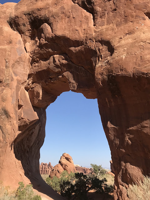


Pine Tree Arch (see the little Pine Tree underneath the arch?)


Balanced Rock


Tunnel Arch


Landscape Arch
They say that somebody mixed up the names between Landscape Arch and Delicate Arch. 
Delicate Arch is that big thick arch that is on the Utah license plates, it is a big honker. 
As you can see Landscape Arch is very delicate

I have to say that I've never seen so my bicycles in my life.  Evidently Moab (the town closest to Arches) is known for being a biking mecca.  There is a whole system of trails throughout the whole region.  You could ride for days and never see the same trail twice.  Moab was a town that definitely catered to the outdoor enthusist.  


I was surprised to see that Utah decorates for Halloween


My original plan was to stay in this part of Utah for several more weeks and then slowly start heading south. I just heard that there is a cold front moving in and the low is supposed to be 19. I know I'm from Minnesota and we scoff at low temps but 19 is a bit much for me. I'm heading south, wimp that I am, tout suite. I only checked out two of the Mighty Five, but that just means I will have to come back.

The night before I left, I picked up a couple of hitchhikers. I was sitting on the couch and I heard this really loud scratching behind a wall. After ruling out ghosts, zombies and other nefarious creatures, I figured I had mice. Luckily I was equipped with mouse traps and peanut butter. I put the trap in a drawer the backside of which was open to the underbelly of the camper. Not more than twenty minutes later, the trap went off. I opened up the drawer and there was a mouse, but not a mouse like anything I had ever seen. It was twice as big as a Minnesota house mouse, had very big ears and super big eyes. I felt bad for the mouse, but it was him or me. I set the trap again because they always say if you have one mouse, there are bound to be more. One half hour later, the trap went off again. This mouse was not in the trap, I think the trap just sort of stunned him. He was still alive and by the time I had gone to the bedroom to get my ski gloves to grab him with, he disappeared. Set the trap again, waited another half hour and the trap went again. This time there was a victim. I've set the trap several times since then with no results so I am officially calling my rig mouse free.


Sunday, October 25, 2020

The Canyons

Onward into Utah and the Mighty Five – National Parks that is.

I found a nice little BLM campground called Horsethief Campground north of Moab. It was my first back-in site on this trip and I had to back in on my blind side. It wasn't pretty, but I got 'er in. It is a great location, I'm 15 minutes from Canyonlands NP and about a half hour from Arches NP. No hookups, but my solar is working great. When I got here on a Sunday there were still a few sites left. The campground has been full every night since then. Every morning, there is a parade of new campers trolling the roads through the campground looking for a site. You walk outside and there will always be somebody asking if you are leaving.


My Campsite

I thought I would start with going to Arches first. I get there fairly early, at least for me, around 10 a.m. and the park was full, they were not letting anybody in. Where are all these people coming from? Quick change of plans and headed for Canyonlands. I decided my new plan of attack would be to do Canyonlands in the morning and Arches in the late afternoon.

Canyonlands is huge.  There are actually three sections - Island in the Sky, Needles and the Maze.  I concentrated on Island in the Sky.  It is the most developed of all the areas.  I did several hikes in the area, the most fun was the one up Whale Rock.  Whale Rock is this huge rock outcrop.  When you look at it from a distance, it looks like a giant whale.  When you get to the top, there are views for miles.  I used to really dislike cairns - cairns are mounds of stones that people build to show where the trail goes.  I used to think they were just people messing with the landscape and I wished they would leave Nature alone.  Now I am grateful since these cairns have, more than once, shown me the way I needed to go.  I used them extensively at Whale Rock.


Guess What!!  Canyonlands has an Arch


The View From Mesa Arch


Another pointy tower


I guess this is why they call it Canyonlands

On the road to Canyonlands, there is Dead Horse Point State Park.  This is a pennisula of land, part of which overlooks Canyonlands.  The legend goes (and sensitive readers might want to skip the next paragraph):

"The point was once used as a corral for wild mustangs roaming the mesa.  Cowboys rounded up these horses and herded them across the narrow neck of land onto the point.  The neck, which is only 30 yards wide, was then fenced off with branches and brush, creating a natural corral surrounded by precipitous cliffs.  The cowboys then chose the horses they wanted and, for reasons unknown, left the other horses corralled on the waterless point, where they died of thirst within view of the Colorado River 2,000 feet below. "

There is an excellent trail that goes around the rim of this penisula. The views were some of the best I've seen in Utah.   I hiked with a woman, Kat, who was visiting from Denver.  It is amazing how fast the miles go when you are talking to an interesting someone.  


The white area in the picture are Potash Evaporation Ponds.
Potash is a potassium-containing salt used in farm fertilizers.
They pump it up from below the Earth's surface into these ponds. 
They add blue dye to speed the evaporation process which leaves behind the Potash


Colorado River


Saturday, October 24, 2020

Black Is Black


Black Canyon of the Gunnison – another canyon, another heart stopping trip to the edge. Black Canyon is, well,  black. Part of it is the rock, but the other part is that it is a very narrow canyon with very tall vertical walls. The Gunnison River flows through the canyon and is responsible for the landscape. If I thought the Colorado Monument had steep drop offs, I had another think coming. According to the brochure, at one point it is 2,250 feet deep. The canyon ranges from a wide spot at Chasm View of 1,100 feet wide to the Narrows which is only 40 feet wide.

I had heard that the way to really see the canyon was to book a boat ride down the Gunnison, but because of Covid, all boat tours have been canceled for 2020. That left me with driving along the rim and getting my nerve up to get near those steep drop offs. I think it was only a six mile drive along the rim. The hard part was that it was really difficult to find any sort of parking space at the overlooks. There are so many people out enjoying their parks. I miss traveling with my little sedan where I could just whip into tiny spots. Now that I'm driving my diesel monster truck (and feeling very macho at that), it is more difficult to squeeze into even regular sites.  Traditionally, the best time to travel in an RV is from Labor Day to Memorial Day. Summer is when all the families take to the road with the little ones They tend to disappear when school starts. That is not happening this year.

I feel like I should apologize for the quality of my pictures. Taking pictures at high noon tends to give them a washed out appearance and they are not as striking as they could be.


Gunnison River


Seems like every park has one lone spire jutting into the air


Way down there is the Gunnison leaving the Black Canyon


It seems the kids have worked out their bed issues


Saturday, October 17, 2020

Colorado National Monument


Greetings from Grand Junction, Colorado. It is a pretty big town, so I'm planning on doing some shopping and getting some chores done.

I'm also going to the Colorado National Monument. If you don't have the lifetime senior pass, it cost every carload $25 to enter the Monument. Not for me though – Free, Free, Free. The ranger actually thanked me for getting the lifetime pass. Never had that happen before. 

I entered the Monument on the western side, from the town of Fruita. It is a steady uphill climb on a very narrow road with big drop offs on the side of the road. This was not a small little uphill climb, we are talking 2300 feet of elevation gain. You have to share these narrow little roads with bikers. I was so impressed with them – can you imagine? When I got to the top, I talked to one biker. He was over seventy years old. He told me that two years and four months ago, to the day, he was in a wheelchair with meningitis and they told him that he would never be able to walk again. Holy cow, he had just gotten to the top of this huge climb. Inconceivable!!

Once you are on the top, the road goes for 23 miles along the rim of the Monument. There were quite a few turnouts to check out the view. I decided that I was going to hike every one of the short trails which ranged from a quarter of a mile to three-quarters of a mile one way. Double that for your mileage count. When I came through the ranger station, he told me it would take about an hour to drive the whole thing, including stopping at a few places. Six hours later, I finally left the Monument. With one exception, the trails were fairly easy as in they were pretty level. My main issue was that I am challenged with following trails – I tend to go right when I should go left and vice versa. It also seems my vertigo/fear of heights has gotten a lot worse since the last time I was high up.


The Road before it got all twisty turny


Independence Monument
John Otto, the father of this park. climbed this every Fourth of July and planted a US flag at the top


Coke Ovens


Independence Monument with the town of Fruita in the background


The hike to Devil's Kitchen was a pretty easy flat trail until the very end. You look up and you have to climb up some slick-rock. That part was OK, it was sort of fun. The problem though is that there was no trail on the rock. You had to figure out how to get up to the Kitchen on your own. I probably took three times as long as anybody else as I veered all over the rocks. But I made it.


Looking out from Devil's Kitchen


And yes, I did get another Junior Ranger badge.  Ranger Justine was a little tough.  Ranger Justine does not accept any half-ass job.  Do it right or go home.  

Friday, October 16, 2020

Wind, Snow and Waterfalls


I continued across Nebraska and spent the weekend at a lovely little place called Oliver Reservoir Recreation Area. It was off-grid so I had a chance to further explore my new solar system. I have to admit, I'm pretty happy with it. The best thing is that I have confidence in it now. One less worry to deal with.


My View


After an idyllic weekend, I finally left Nebraska and headed into Wyoming. I was a little bit worried about the wind.. It was out of the west, so it was a direct head wind. I could tell as my gas mileage really started to tank. Then I saw on the electronic signs that they had “Warning – Extreme Winds 40+ mph – Gusts 60+ mph. I would normally never ever drive with winds like this, but to tell you the truth, I couldn't really tell they were so bad. My rig pulled unbelievably easy. To add insult to injury though, as I drove up the Lincoln Highway and got some altitude, Ms. Weather had the audacity to start snowing.


I got to Rawlins, Wyoming. I had planned to get full hookups and do laundry plus some other chores. Plans change. I could barely get my truck doors closed, the wind was so strong. I hooked up my electric, moved the animals into the camper and settled in while the camper rocked and rolled all night long.


Speaking of plans changed, I had planned to head to Salt Lake City. I was looking at a map and saw that I could just as easily head down into Colorado and see my son, Nate. He lives in Breckinridge and he drove a couple of hours to come and spend the day with me. I was thrilled. I was at Rifle Gap State Park.  The park was aptly named as it was hunting season and you could hear shots off in the distance.  After eating some lunch, we went four miles up the road to Rifle Falls State Park to see waterfalls!!!! My first waterfalls on this trip.  We saw the falls, both from the bottom and then we hiked up to the top.  Seeing my son and waterfalls - life just doesn't get any better than this.  


Rifle Gap


The Campground
I'm at the far left


Thursday, October 8, 2020

The Great Plains Calleth


Usually I can hardly wait to get on the road. It calls to me – it's exciting, dare I even say thrilling? This year not so much. Being cooped up since February has become a way of life. Ennui has set in. Everything seems to be an effort. Staring off into space , doing nothing has become the new normal for me

I decided that I had to shake things up. Do the proverbial 'Kick In The Ass' and motivate. Onward!!

Day 1: Stayed at Pottawattamie County Fairgrounds in Avoca Iowa. I only mention this because:

   a. I like the way the name rolls off the tongue. It is one of those verbally fun words.

   b. I lost a set of keys to the RV. This is the 2nd set of keys to the Camper I've Lost. Can we say Space Cadet?


Pottawattaie County Fairgrounds 

Day 2: I actually get up early, ready to start the day. Dog walked – check. Camper ready to roll – check. I drive about 3 miles and turn onto the westward entrance ramp to I80. I look back and there is a massive amount of smoke coming off the wheel on the camper's driver's side. I immediately pull over. The hub on the wheel is hot. I have roadside assistance, so no problem. The Dispatch Center tells me that probably a wheel bearing froze up. They will have to tow it 50 miles to Omaha. They will also need to get a LowBoy tow vehicle because the camper is 13' tall. A LowBoy is one of those trailers that have a huge drop in the deck height to allow them to transport tall objects. Where are we going to get one of those in rural Iowa? Luckily, they find a mobile tech to come out. Juan was a nice guy. We try to move the camper over a little farther off the road but the wheels are totally locked up. It won't go forward or backwards. What to do? Well, let me tell you. There is a wire that is connected to the brake system in the camper and also to the truck. If, for some reason, the camper gets disconnected from the truck, this wire pulls out from the camper, locking all the brakes. Somehow, that wire had disconnected from the truck, perhaps when I turned onto the freeway? Plugged that sucker back in and all is working. I had Juan take the offending tire off and check to make sure that I hadn't burned bearings or brakes or whatever goes on inside a wheel. I got charged $450 for that little bit of effort. At this point I had spent 4 hours on the side of the freeway being buffeted by all those huge semis – I was in a weakened state. I guess it is a new definition for Highway Robbery. I can tell you one thing though, checking that that wire is connected will be part of my departure checklist.

Day 3: Found my lost keys – I am not going to say where because it would be definite proof that I really am losing it. There were no issues on today's drive. I think I'm very very slowly getting my travel chops back. I decided that I am really going to shorten the amount of time on the road. I have no place to be, no timetable to follow. The animals (Jogger and Miko) get a little stressed out with long hours, so why not take it easy?

I joined an organization called Harvest Hosts. You pay a yearly fee and you can camp at one of their participating sites for free. Most of their sites are farms, distilleries or ...wait for it – wineries. Is this my type of organization or what? There are also various other types of attractions that participate.

I ended up today in North Platte Nebraska at a Harvest Host site, boondocking at the Golden Spike Tower. This tower overlooks the World's Largest Rail Yard which is run by the Union Pacific Railroad.

From the website:  ...reaching a total length of eight miles. ….Each day, Bailey Yard manages 10,000 railroad cars.

The coolest sight was what they called the Hump. An engine pushes a train up a slight incline. At the top, a person disconnects the car from the train, and pulls a lever switching the track for that particular car. The car then rolls downhill, all on its own and connects to whatever new train that will take it to its new destination. It was sort of eerie seeing loose railroad cars sliding down a hill all on their own.


There I am - nothing but corn all around. 
Can we say 'Children of the Corn'?


Golden Spike Tower


It is hard to get a grasp on the whole scoop of the place in a picture


Now I can feel confident in my train dining manners.